More Dams
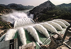
11. Spillway:
A spillway is a structure used to provide the controlled release of flows from a dam or levee into a downstream area, typically the riverbed of the dammed river itself. In the United Kingdom, they may be known as overflow channels. Spillways ensure that the water does not overflow and damage or destroy the dam. Floodgates and fuse plugs may be designed into spillways to regulate water flow and reservoir level. Such a spillway can be used to regulate downstream flows – by releasing water in small amounts before the reservoir is full, operators can prevent sudden large releases that would happen if the dam were overtopped. More details
12. Donnells Dam:
Donnells Dam is a concrete arch dam located on the Middle Fork of the Stanislaus River in Tuolumne County, California. The water impounded by the 291-foot (89 m) high dam forms Donnell Lake in Stanislaus National Forest. The dam and reservoir are co-owned by the Oakdale Irrigation District and South San Joaquin Irrigation District, and the dam is one of three in the Tri-Dam Project. The other two dams in the project are Beardsley Dam and Tulloch Dam. The dam has a length of 750 feet (230 m) at its crest and a storage capacity of 56,893 acre feet (70,176,000 m3). More details
13. Akosombo Dam:
The Akosombo Dam (Volta Dam) is a hydroelectric dam on the Volta River in southeastern Ghana in the Akosombo gorge and part of the Volta River Authority. The construction of the dam flooded part of the Volta River Basin, and led to the subsequent creation of Lake Volta. The flooding that created the Lake Volta reservoir displaced many people and had a significant impact on the local environment. Lake Volta is the largest man-made lake in the world by surface area. It covers 8,502 square kilometres (3,283 sq mi), which is 3.6% of Ghana's land area. With a volume of 148 cubic kilometers, Lake Volta is the world's third largest man-made lake by volume. More details
14. Beardsley Dam:
Beardsley Dam is a dam on the Middle Fork Stanislaus River in Tuolumne County, California. The site is surrounded by the Stanislaus National Forest. The earthen dam was completed in 1957 with a height of 284 feet (87 m), and a length of 1,000 feet (300 m) at its crest. It impounds the Middle Fork of the Stanislaus River for hydroelectric power and irrigation water storage, part of the Stanislaus River Tri-Dam project cooperatively owned by the Oakdale Irrigation District and South San Joaquin Irrigation District. The reservoir it creates, Beardsley Lake, has a water surface of 1.1 square miles, a maximum capacity of 97,800 acre feet, and a normal capacity of 97,500 acre feet. More details
15. Warragamba Dam:
Warragamba Dam is a heritage-listed dam in Warragamba, Wollondilly Shire, New South Wales, Australia. It is a concrete gravity dam, which creates Lake Burragorang, the primary reservoir for water supply for the Australian city of Sydney, New South Wales. The dam impounds the Coxs, Kowmung, Nattai, Wingecarribee, Wollondilly, and Warragamba rivers, within the Hawkesbury-Nepean catchment; and the dam wall is located approximately 65 kilometres to the southwest of Sydney central business district, near the town of Wallacia. Constructed between 1948 and 1960, the dam created capacity for a reservoir of 2,031 gigalitres and is fed by a catchment area of 9,051 square kilometres. More details
16. Tulloch Dam:
Tulloch Dam is a hydroelectric dam on the Stanislaus River in central California. The dam is part of the Stanislaus River Tri-Dam project cooperatively owned by the Oakdale and South San Joaquin Irrigation Districts, and was completed in 1958. It serves mainly for irrigation purposes but also has a power station with a capacity of 18 megawatts. The dam is located just downstream of the New Melones Dam and upstream of the Goodwin Dam. The Donnells dam, Beardsley dam and Tulloch dam projects are located in Tuolumne County, California on the Middle Fork of the Stanislaus River. More details
17. Geehi Dam:
Geehi Dam is a major ungated rockfill embankment dam across the Geehi River in the Snowy Mountains of New South Wales, Australia. The reservoir impounded by the dam is known as Geehi Reservoir. The structure was completed by Thiess Brothers in 1966, and is one of the sixteen major dams that comprise the Snowy Mountains Scheme, a vast hydroelectricity and irrigation complex constructed in south-east Australia between 1949 and 1974 that is now run by Snowy Hydro. The dam is located within what is now the Snowy Valleys local government area. It was constructed by Thiess Bros based on engineering plans developed under contract by the Snowy Mountains Hydroelectric Authority. More details
18. Opuha Dam:
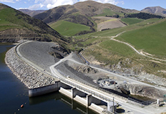
The Opuha Dam, which is situated at the confluence of the North and South Opuha Rivers 17 kms north-east of Fairlie, is an infrastructure project undertaken by the community of South Canterbury. The actual project itself consists of a 50 metre high earth dam, with a single hydro turbine and a lake covering up to 710 hectares and storing over 74 million cubic metres of water. The lake provides water to maintain environmental flows in the downstream catchment and for irrigation as well as urban and industrial supplies. Renewable hydro electricity is generated with all the water released from the dam. More details
19. O'Shaughnessy Dam:
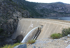
O'Shaughnessy Dam is a 430-foot (131 m) high concrete arch-gravity dam in Tuolumne County, California, in the United States. It impounds the Tuolumne River, forming the Hetch Hetchy Reservoir at the lower end of Hetch Hetchy Valley in Yosemite National Park, about 160 miles (260 km) east of San Francisco. The dam and reservoir are the source for the Hetch Hetchy Aqueduct, which provides water for over two million people in San Francisco and other municipalities of the west Bay Area. The dam is named for engineer Michael O'Shaughnessy, who oversaw its construction. More details
20. Troy Dam:
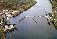
The Federal Dam (Troy) is a manmade dam built across the Hudson River in the U.S. state of New York from Troy on the east bank to Green Island on the west bank. The major function of the dam is to improve navigability. It is located at mile 153 of the Hudson River, measuring from the beginning of the Hudson as a Federally Navigable Waterway near the Battery in Manhattan. The location of the dam marks the upper end of the Hudson River estuary. In order to allow ships to move freely, the eastern end of the dam contains a lock, commonly called the Federal Lock or (on some charts and publications) the "Troy-US Lock". More details